北三方ヶ森 森林縦走をたっぷり楽しめる市境の山(愛媛県松山市・愛媛県今治市)標高977.6m
ふと時間が取れたので、初めての北三方ヶ森へ!
すぐ近くにあるのですが、なかなか気軽に行けない歩行距離。
ようやく、三方ヶ森シリーズに突入できます。
松山、北条、玉川の3つのエリアにまたがる森林エリア。
そのため、三方ヶ森と呼ばれます。
ずっとリサーチしていますが、今回の北三方ヶ森が最も登りやすく、南三方ヶ森、東三方ヶ森はなかなか気合がいりそうです。
中三方ヶ森、西三方ヶ森は、かなりのマニアックさ。
いつの日か全て制覇したいですね。
北三方ヶ森は、王道の高縄山駐車場からスタートです。
車道を下っていくと、コーナーに「北三方」の標識がある登山口が見えてきます。
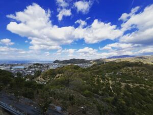
しばらくはしっかりとした道で、途中で北三方ヶ森から、福見山・明神山方面の山々を眺められます。
そのまま進むと、杉林の中の登山口に入っていきます。
小さなピークのアップダウンがありますが、道はとても整備されていて歩きやすいです。
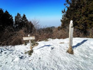
分岐点がいくつかりますが、定期的にテープや北三方ヶ森への標識がありますので、迷うことはほぼないと思います。
走りやすくもありますので、トレランの練習で使いやすい道でもありますね。
前半は杉林、後半は左手が針葉樹、右手が広葉樹の道になります。
私は広葉樹の景色が好きですね。
登山口から北三方ヶ森までは約1時間半の道のりですが、最期の30分ぐらい、標高差140mぐらいがそれなりに急登となります。
土砂崩れで階段が流れてしまっているエリアもありますので、気をつけて登ってくださいね。
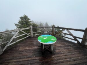
北三方ヶ森の山頂は、テーブルとベンチが設置されていますので、ゆっくり過ごすことができます。
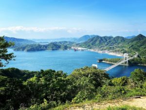
木々で眺望が遮られていますが、隙間から今治市の街の景色と来島海峡大橋を眺めることができます。
ここから水ヶ峠までは3.9km。
時間をたっぷり取れる方は、ぜひ、水ヶ峠までの往復を楽しんでくださいね。


よく整備されていてトレラン向けの道ですね

YAMAPに表示されていませんが歩いてみたい道ですね


土砂崩れを起こしていますので注意して進んでください

テーブルがあり、ゆっくりできるのが良いですね


ただし、木々が邪魔をしているためテーブルの上ぐらいから

#北三方ヶ森
#きたさんぽうがもり
#標高978m
#高縄山
#宝坂谷
#水ヶ峠
#愛媛の小山登り
#小山登り
#愛媛県
#松山市
#今治市
#奥道後玉川県立自然公園
#トレラン
#トレイルランニング
#三方ヶ森シリーズ
Suddenly I had some time to spare, so I went to Kitasanpougamori for the first time!
It is very close by, but the walking distance is not easy to get to easily.
Finally, we can enter the sanpougamori series.
This forest area spans three areas: Matsuyama, Hojo, and Tamagawa.
That is why it is called Sanpougamori.
We have been researching it for a long time, but this time Kita-Kitasanpougamori is the easiest to climb, while Minami-sanpougamori and Higashi-sanpougamori seem to be quite strenuous.
Naka-sanpougamori and Nishi-sanpougamori are quite manic.
I would like to conquer them all someday.
Kitamikatagamori starts at the Takanawa Mountain parking lot on the main road.
As you descend the roadway, you will see a trailhead with a “Kita sanpou” sign on the corner.
The trail is firm for a while, and along the way you will be able to view the mountains toward Mt. Fukumi and Mt. Myojin from the Kita-sanpougamori.
Continuing on, you will enter a trailhead in a cedar forest.
There are some small peaks up and down, but the path is very well maintained and easy to walk.
There are a few turnouts, but you will almost never get lost as there are regular tapes and signs to Kita sanpougamori.
The trail is also easy to run on, so it is an easy trail to use for trekking practice.
The first half of the trail is a cedar forest, while the second half is coniferous trees on the left and broadleaf trees on the right.
I prefer the view of the broadleaf trees.
It takes about one and a half hours from the trailhead to Kitasanpougamori, but the last 30 minutes or so, with an elevation gain of about 140 meters, is a reasonably steep climb.
There are areas where the stairs have been washed away by landslides, so please climb with care.
At the summit of Kitasanpougamorii, tables and benches are set up so you can spend some time relaxing.
Although the view is blocked by trees, you can see the city of Imabari and the Kurushima Kaikyo Bridge through the gaps.
It is 3.9 km from here to Mizugatou.
If you have plenty of time, please enjoy the round trip to Mizugatou.