屋島北嶺 多くの展望台と魚見台がある眺望スポット(香川県高松市)標高282m
屋島南嶺から屋島北嶺へ。
屋島は南北に約5km、東西に約2kmの台地の山。
なかなか距離があります。
一部を除いて、道が舗装道なので、散歩のような感覚です。
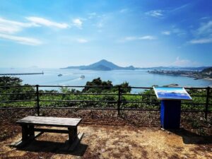
まずは南北の中間地点に、屋島三大展望台の一つ談古嶺があります。
ここからは源平屋島合戦の史跡を堪能することができます。
那須与一の的の場所も見下ろすことができ、歴史を感じますね。
このすぐ先の分岐を北に進み北嶺を目指します。
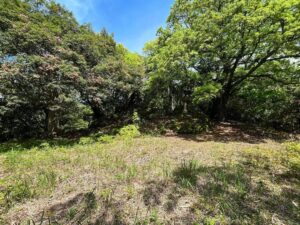
ずっと舗装道もつまらないので、少し山の中に入るコースがあったので入ってみました。
岩の崩落が多いのか、予防のためワイヤー網で山壁が覆われていました。
北嶺には遊歩道上にたくさんの展望台(北・南)、魚見台(東壁・西壁北・西壁南)が作られています。
ぐるっと海ですので、どこでも素晴らしい眺望が楽しめます。
東西の分岐点では東側から回ってみました。
北嶺千間広場は公園としてよく整備されています。
きれいなトイレ&休憩所も設置されています。
北嶺の真ん中あたりで、森の中に入る小道が。
ここを進んでいくと北嶺山頂です。
標識も三角点もありません。
よくわかりませんが、石が積んでありましたので、ここを山頂としました。
いくつかの展望台・魚見台を楽しみながら、最北端へ。
ここに、屋島三大展望台の遊鶴亭展望台があります。
小豆島、鬼ヶ島(女木島)、大槌島と小槌島、直島などの瀬戸内海の眺望を楽しめる良い展望台でした。
山頂駐車場に戻ると約2時間。
鹿島山頂はなかなかの広さでした。


展望台(北・南)、魚見台(東壁・西壁北・西壁南)、遊鶴亭

少し右手の山道に入ってみました

落石対策ですね


左の道に入っていきます

この石積みを山頂とすることにしました
(Instagramでどこかに北峰の木の標識があると教えていただきました)


#屋島北嶺
#やしまほくれい
#標高282m
#談古嶺
#だんこれい
#遊鶴亭
#ゆうかくてい
#展望台
#屋島三大展望台
#屋島
#台地
#メサ
#愛媛の小山登り
#小山登り
#香川県
#高松市
#北嶺千間広場
#千間堂跡
#愛媛の小山登り
#小山登り
#香川県
#高松市
#屋島縦走
#四国百名山
From Yashima Nanrei to Yashima Hokurei.
Yashima is a mountain on a plateau about 5 km north to south and 2 km east to west.
It is quite a distance.
Except for some parts, the paths are paved, so it feels like a walk.
First, at the midpoint between north and south, there is Danko-rei, one of the three major viewpoints of Yashima.
From here, you can enjoy the historical site of the Genpei Battle of Yashima.
You can also look down on the site of Nasu Yoichi’s target, and feel a sense of history.
Just beyond this point, take the branch to the north to reach Hokurei.
The paved road all the way was boring, so we found a course that went a little further into the mountain, so we took it.
The mountain wall was covered with wire netting as a precautionary measure to prevent frequent rock falls.
There are many viewpoints (north and south) and fish viewing platforms (east wall, west wall north, and west wall south) built on the trail at Beiling.
Since the entire area is surrounded by the sea, visitors can enjoy great views from all of them.
At the east-west junction, we went around from the east side.
Beiling Senma Square is well maintained as a park.
There are also clean restrooms and a rest area.
In the middle of Beiling, there is a path into the forest.
This path leads to the summit of Beiling.
There is neither a sign nor a triangulation point.
We are not sure, but there was a pile of stones, so we assumed this was the summit.
Enjoying several viewpoints and fish viewing platforms, we reached the northernmost point.
Here is the Yukakutei Observatory, one of the three major observatories on Yashima.
It was a good lookout from which to enjoy views of the Seto Inland Sea, including Shodoshima, Onigashima (Megijima), Otsuchijima and Kozuchijima, and Naoshima.
Returning to the summit parking lot took about two hours.
The summit of Mt. Kashima was quite large.
遊鶴亭展望台からの眺望(動画)
屋島山上観光駐車場のMAP
屋島南嶺のMAP
談古嶺展望台のMAP
屋島北嶺のMAP
遊鶴亭のMAP