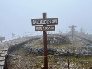
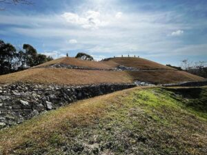
剣山 ガスの中の尾根道コース(徳島県三好市、美馬市、那賀郡那賀町)標高1955m
四国で2番目に高い山、剣山!
最も気軽に登れる百名山、剣山!
ということで家族で剣山に登ってきました。
松山市を6時半に出発して、剣山観光登山リフト駐車場に到着したのが10時。
なんと、既に駐車場がいっぱいです!出遅れています。
なんとか路上駐車でき、準備に入ります。
天気予報は晴れ、気温は7℃。
これから気温が上がることを考えればベストそうです。
まずは見ノ越駅からリフトに乗り、西島駅まで330mを上がります。
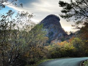
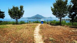
進行先が東ですので太陽がまぶしいのですが、南を向けば三嶺の眺望が最高です!
剣山山頂ヒュッテと次郎岌も見えます。
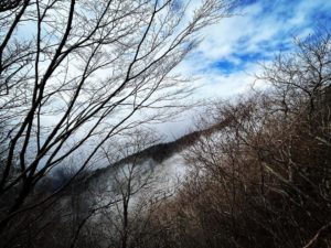
山頂付近は、霧氷で白くなっています。
これは最高なのでは!
と思っていたのですが、西島駅に着く頃には、上空はなんとガスで真っ白に。
山頂までは3コース。
西島駅から山頂までは標高差、わずか200mです。
1.尾根道コース(全長 900m)所要時分40分
2.大剣道コース(全長1200m)所要時分60分
3.遊歩道コース(全長1980m)所要時分80分
ガスの中なので尾根道コースで登ります。
まずは風が強くなってきました。
太陽がないので気温も上がりません。
それでも霧氷が溶け、木々からは土砂降りのように水が降ってきます。
寒い!
合羽を上下とも着込みます。
絶対にいらないと思っていたのですが、備えあれば憂いなしですね。
ガスで視界のない中、黙々と登ってきます。
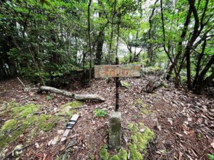
30分ほどで鳥居をくぐり、剣山頂上ヒュッテに。
山頂に向かいますが、極寒の強風で荒れまくっています。
あまりにも寒すぎ、あまりにも風が強すぎるため、家族はヒュッテ前に残し、一人で山頂へ。
寒すぎて気温を測るのを忘れてしまったのですが、体感的には氷点下ぐらいの感覚でした。
吹き飛ばされそうになりながら、遊歩道を猛ダッシュで行ってきましたが、視界はほとんどなし。
次郎岌への稜線が見れず残念でした。
コーヒーで体を温めたら、即、下山。
下りのリフトでは、三嶺がきれいに見えるのですよね。
それでも剣山山頂はガスのままでした。
また、来年、リベンジで登ります。


山頂ヒュッテ下の鳥居に到着です


ガスで視界はほとんどありません

寒すぎるので撤退です
かなり薄着の女の子がお父さんと一緒にいましたが、風邪をひかないことを願っています

#剣山
#つるぎさん
#標高1955m
#けんざん
#鶴亀山
#次郎岌
#じろうぎゅう
#剣山観光登山リフト
#リフト
#見ノ越駅
#みのこしえき
#標高1420m
#西島駅
#にしじまえき
#標高1750m
#剣山頂上ヒュッテ
#平家の馬場
#愛媛の小山登り
#小山登り
#徳島県
#三好市
#東祖谷
#美馬市
#木屋平
#那賀郡
#那賀町
#木沢
#大荒れ
#ガスガス
#霧氷
The second highest mountain in Shikoku, Mt. Tsurugi!
The most easily climbable of the 100 most famous mountains, Mt. Tsurugi!
So my family and I climbed Mt.Tsurugi.
We left Matsuyama City at 6:30 a.m. and arrived at the Kenzan Tourist Lift parking lot at 10:00 a.m. The parking lot was already full!
To my surprise, the parking lot was already full! We were late getting out.
We managed to park on the street and started to prepare.
The weather forecast was for clear skies and a temperature of 7 degrees Celsius.
Considering that the temperature is going to rise from now on, it seems to be the best.
First, we take the lift from Minokoshi Station and go up 330 meters to Nishijima Station.
The sun is shining in the east, but if you look to the south, you will have the best view of the Sanrei Mountains!
You can also see the Kenzan Summit Hutte and Jiro Ju.
The area near the summit is white with fog and ice.
I thought, “This must be the best view!
But by the time we reached Nishijima Station, the sky was completely white with gas.
There are three courses to the summit.
The elevation difference from Nishijima Station to the summit is only 200 meters.
- Ridge trail course (total length 900 m); 40 minutes required.
- Daikendo Course (total length: 1200 m); 60 minutes required.
- Boardwalk course (total length: 1980 m): 80 min.
We took the ridge trail because of the gas.
First of all, the wind was getting stronger.
The temperature did not rise because of the lack of sun.
Even so, the fog and ice are melting and water is falling from the trees like a downpour.
It is cold!
We put on both upper and lower layers of a kappa.
I thought I would never need it, but I guess you can never be too prepared.
We climbed silently up the mountain with no visibility due to the gas.
After about 30 minutes, we pass through a torii gate and arrive at the Tsurugisan Summit Hutte.
We head for the summit, but it is stormy with extremely cold and strong winds.
It is too cold and too windy, so I leave my family in front of the hutte and go to the summit alone.
It was so cold that I forgot to measure the temperature, but it felt about freezing.
I made a mad dash for the boardwalk, feeling like I was going to be blown away, but there was almost no visibility.
I was disappointed that I could not see the ridge line to Jiro-岌.
After warming up with coffee, we immediately descended.
The lift on the way down gave us a beautiful view of the Miune.
Even so, the summit of Mt. Tsurugisan was still in gas.
We will climb again next year with a view to revenge.