象頭山 こんぴらさんの大麻山と象頭山をあわせて「象頭山」(香川県善通寺市)標高538m
ええと、ややこしいのですが・・・
大麻山と隣接する象頭山をあわせて「象頭山」として、瀬戸内海国立公園、名勝、天然記念物に指定されているそうです。
大麻山の鉄塔から出発して、まっすぐの道を下りていきます。
舗装道を嫌がる人が多いのか、草原の中にずっと道ができています。
舗装道が終わったあたりに分岐点があり、象頭山の方面に進んでいきます。
尾根道には、丸金マークの標石が所々あり、こんぴらさんだなぁと思いました。
大麻山から象頭山までは1.5km。
森の小道を歩いていると、あっという間に到着です。
山頂というより、道の途中という感じでしょうか。
眺望はありません。
かわいい象が書かれた標識がありました。
こちらもややこしいのですが、三角点は西へ約500mのあたりにあるそうで、標高は少し低い521.2mとのこと。
更に進むと琴平山です。


戻っても良いのですが
さらにまっすぐ進みます

皆さん、草原の中を歩かれるのですね
どこまでも続く草原の中の道

右手に進んで行きます

木々が低いため草原の中に道が

何の指標なのでしょう?


横にあるのが三角点だと思っていましたが
後で調べたところ、全く違ってました(汗)

GHって何の略なのでしょう?
#象頭山
#ぞうずさん
#標高538m
#愛媛の小山登り
#小山登り
#香川県
#善通寺市
#金刀比羅宮
#ことひらぐう
#こんぴらさん
#瀬戸内海国立公園
#名勝
#天然記念物
At the bottom of the stairs of the Izutama Shrine (Okusha), you will find the trailhead for Mt.Osa.
Finally, we started.
First, you will descend in a zigzag pattern.
After a while, you will come to a fork.
Go straight ahead to the “Aoi no Takihiroba”.
Continue on the path uphill to the Ryuosha Shrine and Mt.Osa.
They had just mowed the grass and it was very bright.
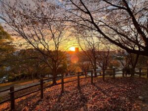
There are places where you can have a beautiful view at a moment.
Because it had rained the day before, the footholds are not good for a while from there.
At this point, a person comes down from above.
I was surprised to see them wearing normal clothes and deck shoes.
They are going to “Aoi no Takihiroba” from the summit plaza.
We parted after introducing the junction point earlier, but we are going back up, right? Will you be all right?
As we climbed up the footpath, we came to the cherry blossom plaza, which is also a junction point.
We headed in the direction of Mt.Osa.
The path becomes a paved road and we walk toward some pylons.
People didn’t like the paved path, so a path was formed in the grassy field.
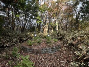
Around the pylons, there was a triangulation point and a masonry marker.
Further in, we came to the summit plaza of Mt.Osa.
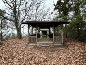
Here is the Mt.Zozu Observatory (Mt. Osa Observatory).
The view toward Mt.Ino.
After enjoying the view, head toward Mt.Zozu.
大麻山(象頭山)の登山口
大麻山のMAP
象頭山のMAP