東三方ヶ森 登山口調査 通信が全く使えません(愛媛県東温市、愛媛県今治市、愛媛県西条市)登山口標高約600m
東三方ヶ森の登山口調査に行ってきました。
阿歌古渓谷の前の木地のバス停を通過し、寺尾重信線を進んでいきます。
四駆の軽自動車以外の車では、決してお勧めしません。
本日はスクーターです。
いきなりの川渡り2ヵ所からスタート。
川を渡ると、波の化石こと漣痕化石のあたりまでは道がしっかりしています。
その後は砂利道に。
どんどんと登っていきます。
問屋林道の標識が見えたら、東三方ヶ森の入り口です。
ここから林道 問屋線に入っていきますが、倒木と落石が多いため歩きです。
林道ですので道はしっかりとしていて歩きやすいです。
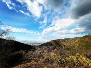
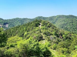
東三方ヶ森を拝めるエリアまでは横に歩く感じです。
そこから谷に向いて下りが始まります。
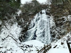
美しい渓谷まで降りると、川に沿って歩いていきます。
入り口から約35分で、東三方ヶ森登山口に到着です。
標高約600mでしたので、標高差600m強の登山となります。
自宅から登山口まで2時間。
登山口から東三方ヶ森山頂まで片道2時間。
なかなか気合いが必要なルートです。
そこから中三方ヶ森まで約1時間とすると
午前8時には登山口に着いておきたいところですね。
さて、あとは「いつ」行くかですね。
ちなみに、木地のバス停の手前から、通信がまったく使えません。
本日は、YAMAPのMAPまで立ち上げていたにも関わらず、リセット&通信エラーでYAMAPが使えず。
「活動開始」ボタンは早めに押しておきましょう!

漣痕化石の標識が目印です

雨後の増水時は危険ですので避けた方が良いですね

木々が生い茂って全く見ることができないのが残念


問屋林道へ入っていきます

その後も落石がたくさんあり、路面も悪いため、歩きが基本となります


この写真では全く伝わらないほど美しいです

ここから山頂まで標高差600mを2時間かけて登っていきます
#東三方ヶ森
#ひがしさんぽうがもり
#標高1232m
#愛媛の小山登り
#小山登り
#愛媛県
#東温市
#山之内
#今治市
#玉川町
#西条市
#丹原町
#登山口調査
#YAMAP
#気合いがいるなぁ
#問屋林道
#漣痕化石
We went to survey the trailhead of Higashisanpougamori.
Passing the Kiji bus stop in front of the Akako Valley, we proceeded along the Terao Shigenobu line.
It is never recommended to drive anything other than a four-wheel drive light car.
Today we are on scooters.
We start with two river crossings out of the blue.
After crossing the river, the road is solid until we get to the ripple scar fossil, which is a wave fossil.
After that, the road becomes gravel.
The path climbs higher and higher.
When you see the sign for the Qoya forest road, you are at the entrance to Higashisanpougamori.
From here, you will enter the forest road, the Tonya line, but you will have to walk because there are many fallen trees and rocks.
Because it is a forest road, the path is firm and easy to walk on.
You will walk sideways until you reach an area where you can see Higashisanpougamori.
From there, the trail begins to descend toward the valley.
Once down to the beautiful valley, you will walk along the river.
After about 35 minutes from the entrance, we arrived at the Higashisanpougamori trailhead.
The elevation was about 600 meters, so the elevation gain is a little over 600 meters.
It took 2 hours from my house to the trailhead.
From the trailhead to the summit of Higashisanpougamori is a one-way trip of two hours.
It is a route that requires a lot of energy.
From there to Nakamikatagamori takes about one hour.
I would like to be at the trailhead by 8:00 a.m.
Now we just have to decide “when” to go.
By the way, communication is not working at all from before the bus stop at Kiji.
Today, even though I had even started up the YAMAP MAP, YAMAP was not available due to a reset & communication error.
Let’s press the “Start Activity” button as soon as possible!